
Introduction
- Climate refers to the average weather conditions of a place over a long period, including temperature, rainfall, and winds.
- This chapter compares the climate of India and Brazil, focusing on temperature, rainfall, winds, and their effects.
- Key skills: Reading maps, graphs, and understanding how geographical features influence climate.
Climate of Brazil
Overview
- Brazil has a wide range of climates due to its vast latitudinal extent (from 5°15’N to 33°45’S).
- Tropical climate dominates near the equator (hot and humid), while a temperate climate is found near the Tropic of Capricorn in the south.
- Most of Brazil lies in the tropical zone, with the equator passing through the northern part.
Temperature
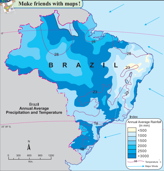
Average Range: 21°C to 28°C (based on isotherms in Figure 4.1).
Northern Brazil (e.g., Amazon valley): Hotter, with temperatures of 25°C-28°C, little seasonal variation due to proximity to the equator.
Southern Brazil: Cooler, with lower average temperatures due to higher latitude.
Coastal Areas: Mild and humid due to the influence of the Atlantic Ocean.
Highest Temperatures: Found in the northern regions near the equator.
Lowest Temperatures: Found in the southern regions near the Tropic of Capricorn.
Rainfall
Main Sources: Rainfall comes from Southeast Trade Winds and Northeast Trade Winds blowing from the Atlantic Ocean.
Types of Rainfall:
- Orographic Rainfall: Occurs when winds hit the Great Escarpment and Brazilian Highlands, causing heavy rain in coastal areas (e.g., 2000 mm in the Amazon valley).
Highest Rainfall: Amazon valley (around 2000 mm annually).
Moderate Rainfall: Northeastern coast (1000-1200 mm).
Rain-Shadow Area: The Drought Quadrilateral in the northeastern Brazilian Highlands receives minimal rainfall (600-800 mm) because the escarpment blocks moisture-laden winds.
Rainy Season: Varies by region, but generally occurs from December to April (based on Figure 4.4).
Winds
Direction: Winds blow from the southeast and northeast (trade winds).
Reason: High-pressure systems in the Atlantic Ocean push these winds towards Brazil.
Obstruction: The Great Escarpment and Brazilian Highlands block the winds, causing orographic rainfall on the windward side and dry conditions on the leeward side.
Equatorial Winds: Between 0° to 5°N/S, winds move vertically (convection), creating a weak convergence zone, which reduces cyclone formation.
Special Features
Tropical Cyclones: Rarely occur in Brazil because:
- The trade wind convergence zone near the equator is weak.
- Winds move vertically, not horizontally, preventing cyclone formation.
- Stable temperatures near the equator reduce cyclone triggers.
Snowfall: Rare, but southern Brazil occasionally experiences snowfall (e.g., in 1879, 1957, 1985) when polar air masses reach the region.
Drought Quadrilateral: A dry region in the northeast with hot temperatures, sparse vegetation, and frequent droughts due to the rain-shadow effect.
City Climate (Based on Figure 4.4)
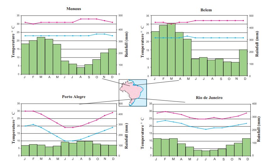
- Manaus: Hot, humid, little temperature variation, high rainfall.
- Belem: Hot, high rainfall, especially from January to May.
- Rio de Janeiro: Warm, humid, moderate rainfall, equable climate.
- Porto Alegre: Cooler, maximum temperature range, distinct seasons.
Climate of India
Overview
- India has a monsoon-type climate, characterized by seasonal winds and heavy rainfall.
- The Tropic of Cancer passes through the middle, making most of India tropical with high temperatures.
- Climate varies due to latitude, altitude, and geographical features like the Himalayas and Indian Ocean.
Temperature
- Average: High throughout the year due to the Tropic of Cancer.
- Maximum Temperatures: Thar Desert, Rajasthan (up to 50°C in Ganganagar in June).
- Minimum Temperatures: Jammu and Kashmir, Himalayas (down to -48°C in Kargil in winter).
- Direction of Increase: Temperature increases from north to south.
- Coastal Areas: Milder due to the Indian Ocean’s moderating effect.
Rainfall
Main Source: Southwest Monsoon Winds (June-September) bring most of India’s rainfall.
Highest Rainfall:
- Western Ghats and Eastern Himalayas (>4000 mm).
- Mawsynram and Cherrapunji in Meghalaya (11,872 mm and 11,777 mm, wettest places in the world).
Lowest Rainfall: Jaisalmer, Western Rajasthan (<120 mm, driest part of India).
Retreating Monsoon: Northeast Monsoon winds (October-December) bring rainfall to Tamil Nadu and parts of the Peninsula.
Types of Rainfall:
- Orographic Rainfall: Caused by the Western and Eastern Ghats and Himalayas blocking monsoon winds.
- Convectional Rainfall: Less prominent in India, occurs in hot, humid conditions.
Rain-Shadow Area: Parts of Gujarat and Rajasthan (e.g., Thar Desert) receive low rainfall because the Aravali ranges block monsoon winds.
Winds
Southwest Monsoon Winds:
- Blow from the Indian Ocean (high pressure) to India’s low-pressure areas (Punjab Plains, Thar Desert) in summer.
- Bring heavy rainfall, especially in coastal areas and the Himalayas.
Northeast Monsoon Winds:
- Retreating monsoon winds blow from the northeast towards the Indian Ocean, bringing rainfall to Tamil Nadu.
Himalayan Influence: Blocks cold northern winds and forces monsoon winds to rise, causing orographic rainfall.
Seasons (Indian Meteorological Department)
- Hot Weather Season: March-May, high temperatures, low pressure develops.
- Monsoon Season: June-September, heavy rainfall from Southwest Monsoon.
- Retreating Monsoon Season: October-December, rainfall in Tamil Nadu from Northeast Monsoon.
- Cold Weather Season: January-February, cooler temperatures, especially in the north.
Special Features
- Natural Disasters: India faces erratic rainfall, droughts, floods, and cyclones frequently due to its tropical location.
- Tropical Cyclones: Common in India, especially in the Bay of Bengal, affecting eastern coastal states.
- Semi-Arid Conditions: Found in Western Andhra Pradesh due to low rainfall in the rain-shadow of the Western Ghats.
- Three-Crop Regions: Parts of India (e.g., West Bengal, Tamil Nadu) grow three crops a year due to high rainfall and fertile soil.
City Climate (Based on Figure 4.5)
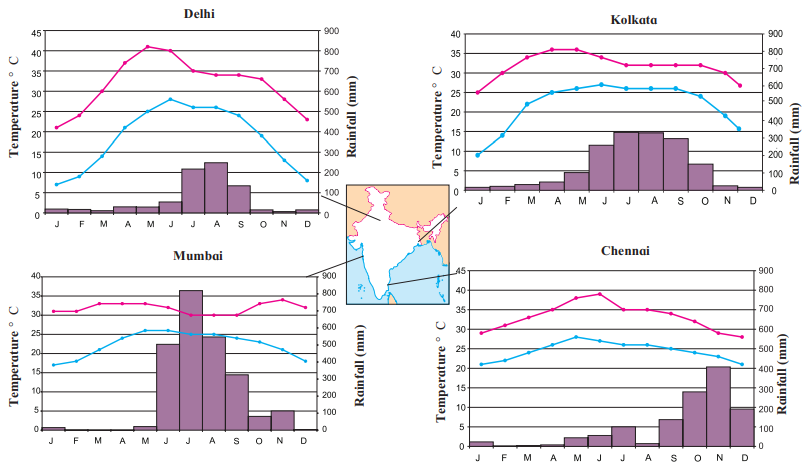
- Delhi: Extreme climate, hot summers, cold winters, moderate rainfall (July-August).
- Kolkata: Hot, humid, high rainfall during monsoon, similar temperature curve to Delhi.
- Mumbai: Equable climate, mild temperatures, heavy monsoon rainfall.
- Chennai: Equable climate, high rainfall during Retreating Monsoon (October-December).
Comparison of Brazil and India’s Climate
Similarities
- Both are tropical countries with hot climates in most regions.
- Both experience orographic rainfall due to highlands (Brazilian Highlands, Himalayas/Western Ghats).
- Coastal areas in both have mild, humid climates.
- Both face natural disasters like floods and droughts.
Differences
Climate Type:
- India: Monsoon-type climate with distinct wet and dry seasons.
- Brazil: Tropical climate with less seasonal variation in the north, temperate in the south.
Rainfall:
- India: Heavy monsoon rainfall (June-September), retreating monsoon in Tamil Nadu.
- Brazil: Rainfall from trade winds, no monsoon, rainy season varies by region.
Winds:
- India: Southwest and Northeast Monsoon winds.
- Brazil: Southeast and Northeast Trade winds.
Cyclones:
- India: Frequent tropical cyclones in the Bay of Bengal.
- Brazil: Rare tropical cyclones due to weak trade wind convergence.
Snowfall:
- India: Common in the Himalayas.
- Brazil: Rare, only in southern regions during exceptional conditions.
Rain-Shadow Areas:
- India: Thar Desert (blocked by Aravalis).
- Brazil: Drought Quadrilateral (blocked by Great Escarpment).
Leave a Reply